CA Fire Status /Check in

Hey all,

Watching the news, things are currently looking pretty bad in a number of areas in California, leading to a natural concern for our many members in the region.

I was just wondering if any forum members in Cali would mind posting their general location and current status.

Thanks.

As of today the combined acres burned of Southern California fires is 230,500. The area is larger than New York City & Boston combined, and currently rates as one of the five largest fires in California history. In Ventura/SB County the total from the “Thomas Fire” accounts for almost 100,000 acres, by far the most burned overall in comparison to the 6 fires still active. 18,000 homes are still considered threatened.

The wind has been less of an issue over the last 36 hours. Ash is falling as far north as Paso Robles and air quality in all surrounding areas is poor. Venues passing out free masks to the public include Home Depot in Lompoc, Albertson’s in Carpinteria, and several other locations, two per person. Predominant north westerly winds that would blow ash and dirty air south is non existent, and it appears in the 10 day forecast that the usual wind pattern will not replace the current w-sw winds along with some Santa Ana wind conditions.

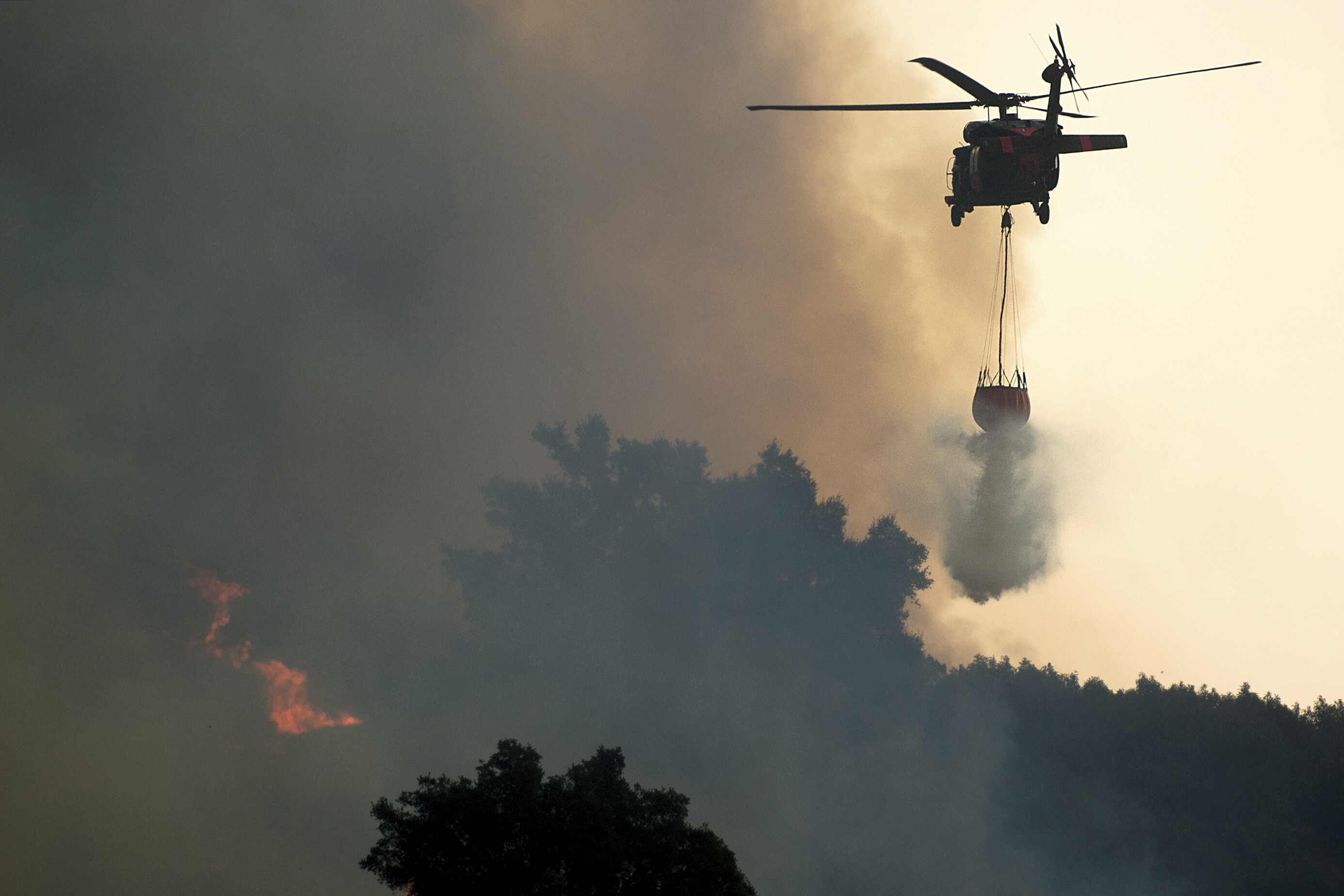
In the Santa Barbara County area, for the most part, the fire is back a ways above the foothills approaching the Camino Cielo ridge. Some creeping down the mountains toward homes behind Carpinteria and Montecito is a concern but lack of winds has helped fire management protect these areas. The fire has had a tendancy to move to the west, which if it continues this path it will reach Hwy 154 ( San Marcos Pass aka Chumash Highway) which will impede the fire as we recently had a fire in and around the Cachuma Lake (I live in Solvang) area, and that fire, with its lack of mature, dry fuel, will serve a similar purpose as a successful back firing operation does. Fire management in this area includes 30 helicopters as well as a retrofitted 747 Jumbo jet that once ran service for Pan Am, this aircraft carries a payload of 24,000 gallons of fire retardant that can be dropped in one or strategic multiple loads. Additional aircraft has been used throughout the duration of this fire in varying degrees depending upon necessity. Current total cost has been accessed at $25 million including six to eight thousand firefighters (and some inmates) working fire lines along with aircraft, tankers, bulldozers and other support related vehicles.

Current containment is at 15% but subject to change depending upon atmospheric conditions changing. Some onshore flow is improving air quality in the Carpinteria to Ventura areas. The duration of this fire is expected to continue to Christmas and quite possibly beyond that date.

Approximately 800 structures have been damaged or lost. The vast majority of these structures were in the Ventura area with smaller loss in Ojai and the Santa Paula/Fillmore area. The large Palm Tree Farm adjacent to Hwy. 101 at Faria Beach was lost but fire crews were able to prevent structure loss at Faria aka Pitas Point.

One loss of life has resulted citing a woman, 70 yrs. of age that is believed to have succumbed to smoke inhalation. I believe she was found in her vehicle in an attempt to evacuate. Mandatory evacuation lines extend east of route 192 behind Santa Barbara/Summerland, and the Mission Canyon areas.


SrPato lives in the Ventura area. A few days ago I checked and they seemed OK. I hope they still are.

The Ventura part of the fire is over for the most part. It was , by far, the worst hit area as far as homes lost. Randy Shaefer, who owns Wave Front Ventura had to evacuate from his home 3x in a 24 hour period. When he and his wife returned, homes 3 blocks down the street were burned to the ground. At that point, the shop was closed for three days. Gary, his manager, lives in Goleta, but couldn’t make the commute as Hwy 101 was closed at times including evacuation at La Conchita where fire fighters actively fought off flames to protect homes from burning. Rincon evacuation did not seem to be as threatened although burn areas were not far off. The other close call was at Faria, as previously mentioned, where winds fanned the fire through the Palm Tree farm which burned so much beautiful vegetation down to stumps or to the ground. The loss of the farm is estimated in the millions of dollars.

Wow that’s crazy. Working in Hollywood I was close to the Sylmar fire and the Skirball fire. The schools here were closed because of the smoke. One of my subcontractors couldn’t get to the job because they shut the I-5 freeway down at Santa Clarita near magic mountain, see pic. There were several l.a. freeway shutdowns last week, but it appears they are open this week, and the sky looks clear from here. The other pics are from Ventura sent by a friend.


I got in touch with Gene Cooper through FB as i was concerned about his factory in Ventura and he told me it was OK although the fire came close, adding that the factory was now Adam Davenport’s but he still works there from time to time.

Up here near Morro Bay (many miles from the fires) we encountered a rather gloomy sky yesterday. You could smell it and taste it but no flames fortunately. I snagged these pics off Facebook. They were taken by Mike Jones @ AZHIAZIAM Surf Shop.


Coming up to 11 PM Sunday night in Santa Barbara - Carpinteria area… the wind has cooperated for fire crews to set back fires behind Carpinteria to prevent the Thomas Fire from moving further west. About a half hour ago around 100 firefighters were in position with rockets, flares and other equipment to set fire in a strategic position to set an entire canyon slope on fire to burn off fuel thereby starving the oncoming fire.

A ridge Edison road was utilized to move heavy equipment in to cut additional fire breaks in key areas earlier today while daylight was still available. Crews worked the entire day setting up positions for making their stand tonight. They have, and are performing several backfires in different areas that will starve the fire of several hundred acres of fuel the fire needs. Containment for the Thomas Fire is currently at 20%.

It went well, so score one for our fire crews. My entire family background (mother, father, brother, aunt, uncle) all have Forest Service history, so this has special meaning to me and, as odd as it may seem, I’m immensely proud of what these folks have accomplished. My gut says they are going to get a much better handle on the Thomas Fire over the next several days. Hope I’m right.

All fires are unpredictable and conditions can change quickly, but a lot of progress has been made behind Carpinteria and along the western perimeter of the Thomas Fire. Many structures, belongings, pets, etc. have been saved through the well organized efforts of fire crews and support staff.

Day 8… http://www.dailymail.co.uk/news/article-5165975/Celebrities-rush-evacuate-California-wildfires.html

The Thomas Fire did a number on Ventura county and is still working its way into Santa Barbara. A number of local surfers lost it all…

A go fund me campaigns have been set up for a number of C-street surf people–two that I know of are:
Bryan Rodriguez and family: https://www.youcaring.com/thebryancarolegonzalesfamily-1038951
Mikey Bob Hasler: https://www.gofundme.com/thomasfire-lizbet-mikey-bob-fund

I’d like to auction/raffle off a board to donate to the victims, but not really sure the best way to do it…


Unless you have more recent info than I do, I talked to Randy, owner of Wave Front a few nights ago and his house survived. He told me he and his wife had to evacuate 3 times in a 24 hour period. They spent the night at the shop. There were houses burned to the ground 3 blocks from him but their house was fine.

Sorry, bad information…deleted.

Here is a link that will help people near burn area and surrounding areas to stay informed on the current air quality. Just click your location automatically or enter the zip code for an area you are interested in.
https://www.airnow.gov/index.cfm?action=airnow.local_city&zipcode=93003&submit=Go

…no worries, he just texted me. All ok…

Today is Thursday. 30% contained, but the unthinkable has happened. Tragedy comes with dangerous jobs. The element of risk is high and it takes a special breed of human to take on jobs like a fire fighter.

Update" Firefighter Cory Iverson from San Diego made a May Day call but was unable to be rescued, an investigation is being conducted.

There are 8,144 firefighters on the job, but as of today, we lost one. One is one too many, especially when you lose a 32 year old husband and father of a two year old. Iverson was assigned to the fire as a part of a strike team from Cal Fire’s San Diego unit. He started with Cal Fire in 2009. He is survived by his wife, Ashley, and their 2-year-old daughter Evie. The family is expecting a second daughter this spring.

Backfires set today and this late afternoon are predictably affecting air quality in the adjacent areas and affects of the air quality is being observed as far north as San Francisco.

For the Air Quality Index go here: https://cfpub.epa.gov/airnow/index.cfm?action=airnow.local_city&mapcenter=0&cityid=288

http://www.dailynews.com/2017/12/14/firefighter-sounds-mayday-alert-as-thomas-fire-rages/

deleted

Interesting how, for the most part, the chart indicates a drop in deaths in the later years with a few incongruities here and there. The fire science has improved over decades of fire fighting as technology is improved and strategic fire fighting is very evident on this huge monster of a fire.

These agencies have done a tremendous job in coordinating while protecting homes and one another. It’s just a shame we have to lose anyone in such disasters.

Today is Saturday 8:30 A>M>… fire is at it’s worst with 259,000 acres burned. The winds N-NE have come up. Fire is currently 40% contained. May not hold at that but fire on the western flank above Montecito is progressing rapidly to the west. New mandatory evac areas have been extended from Hwy 154 east to Mission Canyon. East Camino Cielo is to evacuate along the top of the mountain range north of APS, south of 101 to the coast…and east to the Zoo. Head Captain is calling it a “perfect storm scenario for the fire in doing what they hoped it would not do, and people using garden hoses to think they are making a difference with 65 mile an hour gusts, need to get the hell out and let the professionals do their job”.

The message is GET OUT now… south 192 to 101, west to Toro Canyon, East of Summit Rd… hundreds of fire engines are positioned at homes in the line of fire, 32 helicopters are in service for their maximum run times of 7 hrs. each. Jetliners are in service whereever they can be deployed. Fixed wing aircraft are compromised in heavy winds being created by the fire, Homes have had Fos Chek dropped on them. Flames are within one block of Westmont College. 10,000 residents are currently being evacuated.

Lookey loues, bloggers, selfie addicts, thrill seekers, well intending home owners with garden houses… get the hell outta the way and don’t become a liability.

Voluntary areas include upper State Street, south of Salinas Street, all of Montecito and the Riviera area… fire is moving west extremely fast with high winds.


https://www.seattletimes.com/nation-world/los-angeles-fire-started-in-homeless-camp-officials-say/

If that is true, is incredible how dumb a person could be to not care how to make a fire to cook…and ruin everything around

Hi reverb. Many of the homeless people in our country are mentally disabled, on drugs, or both. It’s a shame and a disgrace. Many just prefer and choose this life style. Mike